Deviation Actions
![Midgard - Political Map, Hol 8 - [OLD VERSION]](https://images-wixmp-ed30a86b8c4ca887773594c2.wixmp.com/f/d92da121-122c-4f6e-8ff9-9b90874cdb51/d970day-d96b46d0-301d-4e36-aeb1-4640f64fc341.png/v1/crop/w_92,h_92,x_7,y_0,scl_0.019311502938707,q_70,strp/midgard___political_map__hol_8____old_version__by_tomme23_d970day-92s.jpg?token=eyJ0eXAiOiJKV1QiLCJhbGciOiJIUzI1NiJ9.eyJzdWIiOiJ1cm46YXBwOjdlMGQxODg5ODIyNjQzNzNhNWYwZDQxNWVhMGQyNmUwIiwiaXNzIjoidXJuOmFwcDo3ZTBkMTg4OTgyMjY0MzczYTVmMGQ0MTVlYTBkMjZlMCIsIm9iaiI6W1t7ImhlaWdodCI6Ijw9NDc2NCIsInBhdGgiOiJcL2ZcL2Q5MmRhMTIxLTEyMmMtNGY2ZS04ZmY5LTliOTA4NzRjZGI1MVwvZDk3MGRheS1kOTZiNDZkMC0zMDFkLTRlMzYtYWViMS00NjQwZjY0ZmMzNDEucG5nIiwid2lkdGgiOiI8PTYxMjkifV1dLCJhdWQiOlsidXJuOnNlcnZpY2U6aW1hZ2Uub3BlcmF0aW9ucyJdfQ.xFyi5SlRfTayRtISVgMRutGv25cX0Ip6Wb4QS3TAp5A)
![Midgard: A Fantasy World Map - [OLD VERSION]](https://images-wixmp-ed30a86b8c4ca887773594c2.wixmp.com/f/d92da121-122c-4f6e-8ff9-9b90874cdb51/d7hmho0-52a20719-7997-4848-9f88-5c92a47bed1b.png/v1/crop/w_92,h_92,x_7,y_0,scl_0.057934508816121,q_70,strp/midgard__a_fantasy_world_map____old_version__by_tomme23_d7hmho0-92s.jpg?token=eyJ0eXAiOiJKV1QiLCJhbGciOiJIUzI1NiJ9.eyJzdWIiOiJ1cm46YXBwOjdlMGQxODg5ODIyNjQzNzNhNWYwZDQxNWVhMGQyNmUwIiwiaXNzIjoidXJuOmFwcDo3ZTBkMTg4OTgyMjY0MzczYTVmMGQ0MTVlYTBkMjZlMCIsIm9iaiI6W1t7ImhlaWdodCI6Ijw9MTU4OCIsInBhdGgiOiJcL2ZcL2Q5MmRhMTIxLTEyMmMtNGY2ZS04ZmY5LTliOTA4NzRjZGI1MVwvZDdobWhvMC01MmEyMDcxOS03OTk3LTQ4NDgtOWY4OC01YzkyYTQ3YmVkMWIucG5nIiwid2lkdGgiOiI8PTIwNDMifV1dLCJhdWQiOlsidXJuOnNlcnZpY2U6aW1hZ2Uub3BlcmF0aW9ucyJdfQ.XbavUrSnWqhBWlZTc5qtcaunL1SEcv4Xt6rPEEsxxis)
![Midgard - Political Map, 2E 191 - [OLD VERSION]](https://images-wixmp-ed30a86b8c4ca887773594c2.wixmp.com/f/d92da121-122c-4f6e-8ff9-9b90874cdb51/d8y78c4-5ce72a05-b824-4c5b-90a2-f22abb5db597.png/v1/crop/w_92,h_92,x_7,y_0,scl_0.019311502938707,q_70,strp/midgard___political_map__2e_191____old_version__by_tomme23_d8y78c4-92s.jpg?token=eyJ0eXAiOiJKV1QiLCJhbGciOiJIUzI1NiJ9.eyJzdWIiOiJ1cm46YXBwOjdlMGQxODg5ODIyNjQzNzNhNWYwZDQxNWVhMGQyNmUwIiwiaXNzIjoidXJuOmFwcDo3ZTBkMTg4OTgyMjY0MzczYTVmMGQ0MTVlYTBkMjZlMCIsIm9iaiI6W1t7ImhlaWdodCI6Ijw9NDc2NCIsInBhdGgiOiJcL2ZcL2Q5MmRhMTIxLTEyMmMtNGY2ZS04ZmY5LTliOTA4NzRjZGI1MVwvZDh5NzhjNC01Y2U3MmEwNS1iODI0LTRjNWItOTBhMi1mMjJhYmI1ZGI1OTcucG5nIiwid2lkdGgiOiI8PTYxMjkifV1dLCJhdWQiOlsidXJuOnNlcnZpY2U6aW1hZ2Uub3BlcmF0aW9ucyJdfQ.TnXfvBA9dHJMME3mrTpn3LbIPJ1cO5xrBj43u3ElFdI)

![Midgard - Political Map, 3E 1 - [OLD VERSION]](https://images-wixmp-ed30a86b8c4ca887773594c2.wixmp.com/f/d92da121-122c-4f6e-8ff9-9b90874cdb51/d8xaz60-45973ba3-248a-429b-98e9-9a22edb2f915.png/v1/crop/w_92,h_92,x_7,y_0,scl_0.019311502938707,q_70,strp/midgard___political_map__3e_1____old_version__by_tomme23_d8xaz60-92s.jpg?token=eyJ0eXAiOiJKV1QiLCJhbGciOiJIUzI1NiJ9.eyJzdWIiOiJ1cm46YXBwOjdlMGQxODg5ODIyNjQzNzNhNWYwZDQxNWVhMGQyNmUwIiwiaXNzIjoidXJuOmFwcDo3ZTBkMTg4OTgyMjY0MzczYTVmMGQ0MTVlYTBkMjZlMCIsIm9iaiI6W1t7ImhlaWdodCI6Ijw9NDc2NCIsInBhdGgiOiJcL2ZcL2Q5MmRhMTIxLTEyMmMtNGY2ZS04ZmY5LTliOTA4NzRjZGI1MVwvZDh4YXo2MC00NTk3M2JhMy0yNDhhLTQyOWItOThlOS05YTIyZWRiMmY5MTUucG5nIiwid2lkdGgiOiI8PTYxMjkifV1dLCJhdWQiOlsidXJuOnNlcnZpY2U6aW1hZ2Uub3BlcmF0aW9ucyJdfQ.16V5tgwEmBSxZi7Os45UbNYNF-Pd7VQZr6IJATNxJ8o)
![Midgard - Political Map, 5E 1 - [OLD VERSION]](https://images-wixmp-ed30a86b8c4ca887773594c2.wixmp.com/f/d92da121-122c-4f6e-8ff9-9b90874cdb51/d8wehlm-64b1329f-9744-4c98-b8a8-d156be7c9422.png/v1/crop/w_92,h_92,x_7,y_0,scl_0.019311502938707,q_70,strp/midgard___political_map__5e_1____old_version__by_tomme23_d8wehlm-92s.jpg?token=eyJ0eXAiOiJKV1QiLCJhbGciOiJIUzI1NiJ9.eyJzdWIiOiJ1cm46YXBwOjdlMGQxODg5ODIyNjQzNzNhNWYwZDQxNWVhMGQyNmUwIiwiaXNzIjoidXJuOmFwcDo3ZTBkMTg4OTgyMjY0MzczYTVmMGQ0MTVlYTBkMjZlMCIsIm9iaiI6W1t7ImhlaWdodCI6Ijw9NDc2NCIsInBhdGgiOiJcL2ZcL2Q5MmRhMTIxLTEyMmMtNGY2ZS04ZmY5LTliOTA4NzRjZGI1MVwvZDh3ZWhsbS02NGIxMzI5Zi05NzQ0LTRjOTgtYjhhOC1kMTU2YmU3Yzk0MjIucG5nIiwid2lkdGgiOiI8PTYxMjkifV1dLCJhdWQiOlsidXJuOnNlcnZpY2U6aW1hZ2Uub3BlcmF0aW9ucyJdfQ.WTzNYTKLvOfNk3jAuWdv35zO39ov8NNMxJQMPOUypWk)


Description
:origin()/pre02/020d/th/pre/f/2015/352/d/d/imperial_city_map_legend_by_tomme23-d9kk0a5.png)
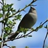
Icons come from the map featured in the Elder Scrolls Online.
I love this! The in-game scales and proportions don't bother me that much, since everything is by necessity and playability scaled down, but on a lot of maps where people attempt to make "real-scale" maps of Tamriel, they still make Lake Rumare and the Niben river as big as they are on Bethesda's official maps, which just makes absolutely no sense at all. I'm not even sure how a river like the Niben would work if it was the width of the English Channel.
This is a lovely inference about what a more "lore-accurate" central Nibenay would look like.
I've had ideas like this to make maps of a "de-compressed" Vvardenfell, but i'm not sure if I could go for a real-scale, or just something between game and realistic. A sort of heightened version, as it were.